| |
 I'm always on the look-out for good hikes. And I particularly like itineraries that lead from A to B instead of from C to C, with C being my car, and me hiking a silly circle around it. Back in Switzerland, where I'm from, hiking from A to B is an easy feat: Start hiking, go until you've had well enough, and then look for public transportation nearby to take you home. With Switzerland's world class system of public transportation, chances are high you won't be more than a hour's hike away from a well-serviced bus stop or train station, no matter where you are.
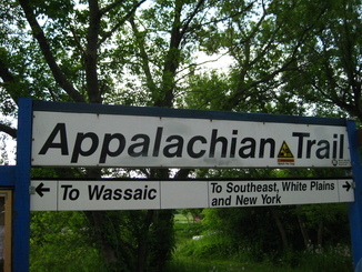
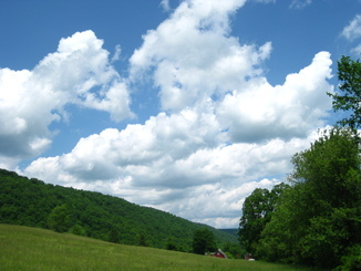
Well. Not so in New York, which is my new home. I was therefore intrigued when I noticed a train station called "Appalachian Trail" on the network map of NY's Metro North, and soon found out thereafter that yes, the train indeed stops right on top of the famous AT, but only on weekends. A little research later, I had my first multi-day hike in NY that was relying solely on public transport all planned out (show map) - it would take me from the AT train station near Pawling, NY, along the Appalachian Trail, all the way to the Hudson River and Bear Mountain Bridge, and from there south to the train station in Peekskill NY. Route data that I had downloaded from http://www.appalachiantrail.org/gis, as well as my own guesstimate for the Bear Mountain Bridge to Peekskill leg, came up with a total of between 45 and 50 miles. Hiking it on a weekend would be pushing it, but hiking it over a three-day weekend should be doable.
Which of course assumed that I wouldn't squander half of the first day. I was lazy getting started, and missed the first train leaving Grand Central at 7:46AM. The second and last train for the day was at 9:48, and got me to the Appalachian Trail stop at close to noon. If I was to make the 18+ miles to my intended first night stop, I'd better hustle... Fresh from a week of office-chair-induced hike deprivation, I made quick work of the first 11 miles up to the Morgan Stewart Shelter. Nobody there, and the privy (loo) suspiciously enough located on the hill *above* the shelter's water pump. No wonder they recommend you purify the water. The shelter didn't look too inviting either - I was kinda pleased that I hadn't intended to stay anyway, snacked an Almond Cherry Clifbar, and hiked on.
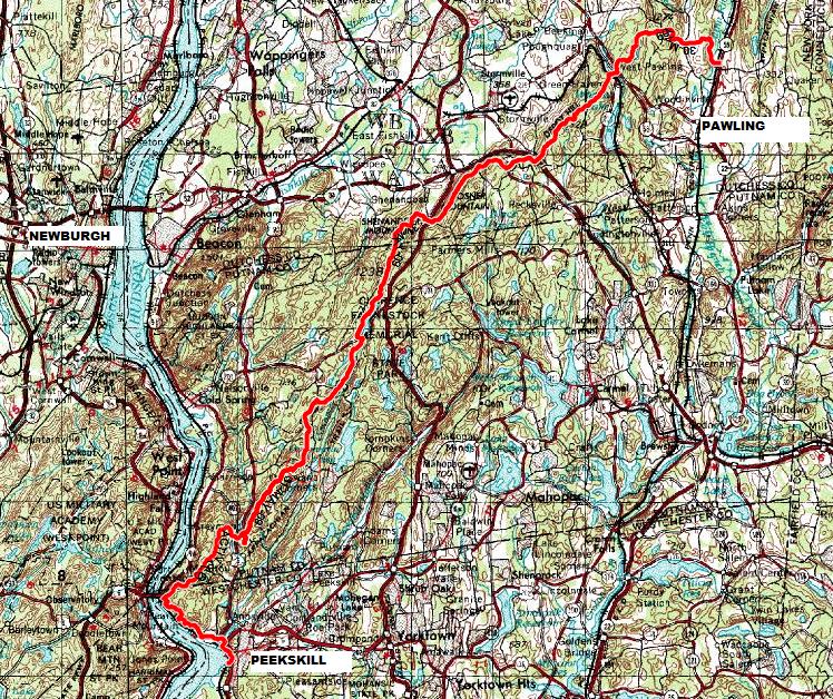
 Two miles or so later, the trail leads across an overpass over I-84, past a couple of home owners who don't seem to like AT hikers, and back into the woods. Uphill again, of course. Chatting with a hiker who was going northbound, we determined that the AT is "uphill in both directions". It really doesn't matter if you go southbound or northbound - you'll get the same hills to climb and descend again. Up on Stormville Mountain, with a nice view to the northwest, I actually consulted my GPS to find out the time of sunset. 8:20pm, the GPS opined, and projected that I would arrive at the RPH Shelter, my destination, around 8pm. Cutting it a bit fine there, so in spite of my growing appetite I didn't linger to have another snack. A little later, I started to hear the traffic on the Taconic Parkway, but since the parkway runs parallel to the AT in the valley below, it still took way longer than expected until I finally popped out of the woods and could cross under the Parkway at the Shenandoah Road exit. The RPH shelter was not even half a mile further. Yay, my Day-1 objective reached! And what a nice shelter it was! RPH is a three-walled cabin (open on one side) and actually contains bunk beds. You still need your mat and sleeping bag of course, but even with a decent mat, it feels good to be off the floor. The shack also has a covered picknick table outside. When I got there as latish as I was, the two northbound hikers already there were about ready to tuck in for the night, but stayed up to chat while I cooked my dinner. I'd recommend you don't use the well water of RPH, btw, I don't think it is bacteriologically bad, but rust colored and with a metal taste. Since you need to filter anyway, the lil' creek about 300ft to the NW of the shelter has better water.
 Day two started as a surprisingly chilly morning. I had a quick breakfast of hot oatmeal, and then bid goodbye to the two Northbounders who were still procrastinating. Knowing I had a ruff climb up to Shenandoah Mountain ahead of me, I didn't mind the early cold one bit, I knew I would get plenty warm soon enough. And indeed, I even managed to get my tshirt pretty wet from sweat by the time I reached the top - no matter how cold it is, zipping up a steep 300m ascend with a backpack strapped on never fails to drive the last cobwebs of slumber from the system...
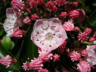 Shenandoah Mountain features nice views, a USGS survey marker, and a Flag painted onto the rock in tribute of 9/11. After soaking up some morning sun and supplementing my earlier breakfast with a cup of Ovaltine, I proceeded downhill further along the white blazed trail. The white and babypink flowers on the mountain laurel were just starting to open, adding their bright dots to the forest green. I had been at Canopus Lake in Fahnestock State Park before, to mop up some Geocaches, but I'd never hiked along the western shore of the lake. Nice views, albeit slow going at times over rocky stretches. If you're into Geocaching, there is one that you can walk to when Canopus Lake is frozen solid but which can only be reached by boat in Summer. I went for it late this spring, and my somewhat foolish dash across the not very convincing ice/slush is not something I'd dare to repeat :). From the south end of Canopus Lake, the trail thankfully enough follows what appears to be an old mining railroad grade: gently sloped, free from obstacles, extremely pleasant after all the careful scrambling earlier.
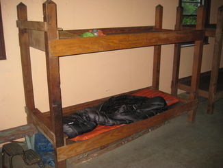
It was only like 11AM when I reached Dennytown road. Another 10 or so miles done, and admittedly I was getting a bit tired. A lunch and a short nap 'neath a tree, as well as a bellyful of cold and tasty water from the Dennytown campsite tap, gave me the energy to push on again. By the time I reached the climb to Canopus Hill, it started to rain and then to pour, but one quick glance up to the sky told me that things weren't serious - loose clouds with the sun peeking through here and there. Still, without the friendly cover provided by the forest, I'd have gotten drenched through and through. Not that I wasn't drenched anyway by the time I got up to Canopus, that's one mean little climb! Onwards, up Denning Hill (there's always one more hill) and finally finally the coveted sign next to the trail that says "Welcome, Hikers, to Graymoor. Please follow the blue blazes to the shelter".
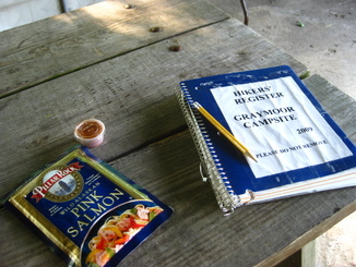 Graymoor is an institution on the AT. A Franciscan Friary, they started providing shelter to hikers back in 1972. Their shelter itself, located next to the ballfield of the Friary, is basic in design, but extremely luxurious in terms of amenities. First, you can get a (cold water) shower in a shack right next to it. Second, the shelter has electric lights and power outlets to recharge your phone or iPod or whatever else you carry that needs juice. Third, some of the friars stop by in the evening to check on their guests, and they are a witty and wise folks to chat with. Surprisingly enough, I was the only night guest that Sunday evening. Knowing I had only about 12 miles to go to Peekskill and wouldn't be spending another night, I splurged on my provisions and had a double dose of Polenta with beef jerky and chili powder for dinner. And a baggie of salmon, with more chili powder, for dessert. Yum! While I prepared for the night, another five or so people stopped by to chat, out walking their dog. This must be one of the most sociable AT shelters around :)
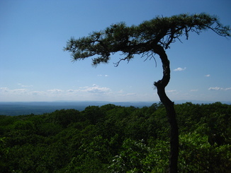
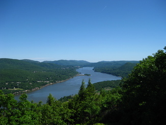 Morning of Day #3 arrived after a deep slumber. The church bells up at the Friary were doing their elaborate ding dong that fondly reminded me of my home in Switzerland. There ain't enough church bells marking the hour in America - or if there are, their music is drowned out by freeways and factories nearby. Having the clear tone of a bell rise into the crisp morning air is .. just nice. Another couple of early dog walkers stopped by to chat while I was cooking yet another Oatmeal and then packing up. At first, when I had scouted out the route on the map, I had considered descending from White Rock over the NYNJTC blue trail down to the train station in Garrison. This would have been around 5 miles out of Graymoor, and mostly downhill. But it also would have made me miss the spectacular view from the rock tip called "Anthony's Nose" down to Bear Mountain Bridge and upstream to West Point and beyond. So I followed the AT all the way to where the trail starts descending to Hwy 9D, and the blue-blazed "Camp Smith" trail splits off. Following the blue trail, I got to "Anthony's Nose". Spectacular, as expected. I particularly liked the view from the sloping granite patch located behind the fundament of the old signal tower, on the north side of the nose. It offers a much nicer view up the Hudson than the main viewpoint on Anthony's.
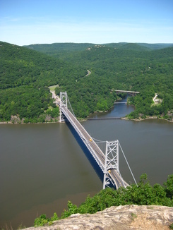 From there, the blue trail leads over ups and downs of rocky ledges, out to the cliff for a view and then back in and thru a ravine or two, until the trail descends to US-6 and ends in ... a parking lot. Yup. This is where you'll wish you have a car waiting for you. Because the next mile and half, until you are across Peekskill Inlet, actually is hardcore road walking on a road that has no sidewalks, crazy drivers, lotsa trucks, and little room to spare. It's the price you pay for the previous 45 miles of gorgeous hiking, and a stretch you'll have to conquer to get to Peekskill train station. I fastened my "don't shoot me I'm a hiker" signal orange vest that I always carry irrespective of hunting season onto the back of my pack, and headed out on the pavement. Once past the intersection with US-9, there is finally a sidewalk of sorts to cross the bridge, and a couple 100ft past the bridge, you can descend off the busy road again. The last mile to Peekskill station follows a narrow lane past a shabby section of storage sheds, junkyards, garages and such. Not necessarily a stretch I would like to hike after dark, but pleasant enough at noon.
Almost exactly 48 hours after starting out at the AT train station near Pawling, I reached the train station in Peekskill. According to my GPS, the entire stretch measured 48.03 miles. And, best of all, express trains to Grand Central leave Peekskill only once per hour, so you should have on average 30 minutes to check out the brew pub (www.thepeekskillbrewery.com) right next to the station. Luck was smiling on me - I got 40 minutes. After 48 hours of hiking and drinking only water drawn from creeks and ponds and questionable wells, there's nothing like a cold beer in a frosty glass :)
RPH Shelter: 41 30.869/-73 47.550
Graymoor Shelter: 41 20.837/-73 55.170
Blue Trail (Camp Smith Trail) leaves AT: 41 19.427/-73 58.122
For more coordinates, also for alternate spots to overnight, see http://www.appalachiantrail.org
For train schedules, see http://www.mta.info Note: The AT train stop is only serviced on Sat/Sun!
My hikes in Utah and Arizona
The standard disclaimers apply to this write-up. Injuries you might encounter on this trek range from a small blister all the way to a spectacular death by being snacked on by a bear, getting blown up in a mess when an electrical spark from your flashlight ignites the methane gas in the privy, falling off a cliff and getting impaled on a pine tree halfway down, etc etc. There is nothing as likely to lead to death as life itself. Deal with it, but don't blame me.
|
|